
For several years, the Google Flood Forecasting Initiative has been working with governments to develop systems that predict when and where flooding will occur—and keep people safe and informed. Google has recently partnered with the Bangladesh Water Development Board (BWDB) and the Access to Information (a2i) Programme to bring the Google Flood Forecasting Initiative to Bangladesh, which experiences more flooding than any other country in the world.
Google currently covers more than 40 million people in Bangladesh, and has been working to extend the flood forecasting to the whole country. To date, they have sent out almost 1 million notifications to people in flood-affected areas across the country.
On this occasion, Md. Arifuzzaman Bhuyan, Executive Engineer, Flood Forecasting and Warning Center, Bangladesh Water Development Board, said, “Floods have affected Bangladesh for many years, devastating the lives of people around the country. This year, more than one-third of the country was under water, and more than 5 million people were severely affected by this national disaster. In this regard, flood forecasting has been proved as an effective flood mitigation measure for Bangladesh. The BWDB-a2i-Google joint flood forecasting initiative paved the way to overcome this challenge and launch the inundation modeling system along the Jamuna-Padma river belt in 14 districts using advanced technology. I’m happy to see how our partnership has helped people across Bangladesh so far, and I look forward to how we can work with Google to improve and protect more lives from floods in the future.”
Anir Chowdhury, Policy Advisor, a2i Programme, People’s Republic of Bangladesh, added, “Based on the very promising preliminary results, we are excited about the system’s potential for dramatically improving forecasting in this flood-prone country. As the Bangladesh government’s flagship digital transformation program, a2i is planning to deepen the work with Google and BWDB to extend the system to the lowest tier of local government.”
For all the progress that Google has made with alert technology, there are still a lot of challenges that the organization needs to overcome. COVID-19 has delayed critical infrastructure work, adding to the immense pressure on first responders and medical authorities, and disrupted the in-person networks that many people still rely on for advance notice when a flood is on the way.
There is much more work ahead to strengthen the systems that so many vulnerable people rely on—and expand them to reach more people in flood-affected areas. Along with its partners, Google will continue to develop, maintain, and improve technologies and digital tools to protect communities and save lives.
How-to guide:
Here’s how to get useful information on flood-affected areas on your smartphone or desktop
The monsoon season of 2020 has seen some of the most devastating floods in many parts of Bangladesh, with many people across the country continuing to grapple with the effects of the flooding. Especially in regions near water bodies like rivers, sustained torrential rain can result in a rapid rise in water levels, putting hundreds of thousands of people at risk. Over the past several months, along with the Bangladesh Water Development Board (BWDB) and Access to Information (a2i), Google has deployed its flood forecasting initiative and sent numerous public alerts to people in impacted regions across Bangladesh. These alerts provide timely, updated, and critical information that can help users make informed decisions on the safety of their families and friends. Any user in the affected region with an Android smartphone with location services enabled will receive these alerts.
Here is an example of the notification shown to users who have location services turned on to help people understand how they can effectively use and interpret the alerts that Google can place in an area expected to be impacted by an impending flood.
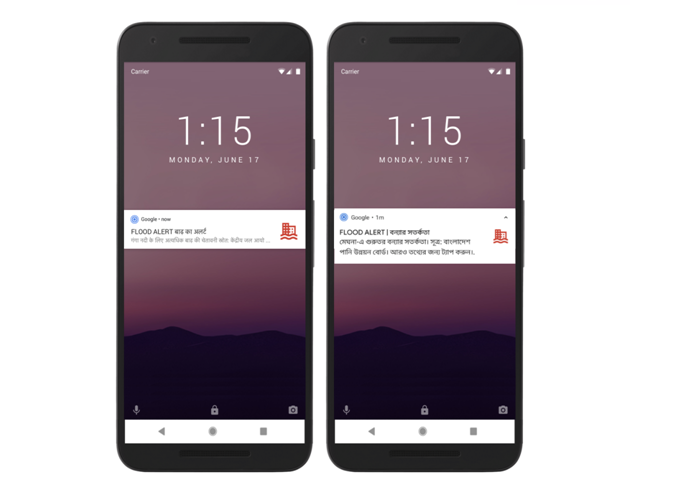
Google is currently issuing these notifications in English and Bangla, depending on a person’s device language and location.
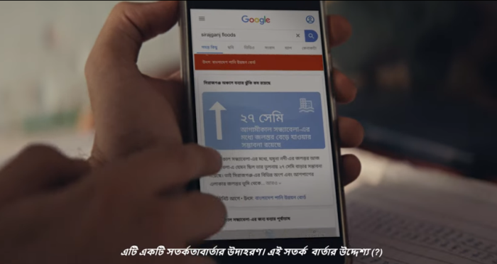
Use Search to simply enter a query on a flood-affected area to view the key information on the current situation in the specified region. See the example below (note that this information is timely and may change depending on whether there was a flooding situation when the query was made).
- Multilingual support (mobile only)
- An indication of the severity of the flooding
- Location chips to enable people in the affected area that people can tap to easily change the search results and get information on more specific locations in their search area
- An infographic showing depth information, which is highly relevant for people in affected areas
- A localized risk statement explaining the change in the scenario.
- An indication of the time of the prediction
- Where possible, Google will provide a detailed color-coded risk map of the areas likely to be inundated with flooding
- A legend helping users interpret the map
Suppose there is a current flooding situation in an area. In that case, users will see a visual overview of essential information, including the rise or fall of the water level in the next day with a description of the situation containing specific guidance where available. You will also see a color-coded map indicating the flooded areas — clicking on this map will open a larger, more detailed view in Google Maps, where you can zoom in to understand water levels in specific regions. You can use this feature from any neighborhoods across the nation by searching for ‘flooding’ and the name of an affected location on Search or Maps; it can be very useful to stay updated, especially if you have friends or family in the affected areas.
Google will continue to remain committed to using technology to help people, especially during natural disasters, and continue to work closely with local authorities to bring timely, relevant, and useful information to people who most need it.


